
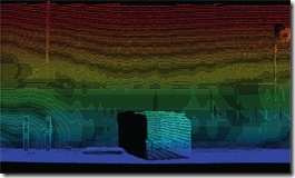
The latest music video by RadioHead was made with LIDAR data. They used the mobile Velodyne system for the portions that show complete environments. For 3D plots of the singers a system from GeoMetric Informatics was used. The Velodyne system was the same system used by the top 2 robot cars in the DARPA Urban challenge (link).
And if you don't know what LIDAR is - it stands for LIght Detection And Ranging. It works on a similar principle as RADAR and SONAR, except instead of radio waves or sound waves - it uses light to determine distance between the sensor and the reflecting surface. And as it is using light (typically lasers), it has a very high resolution.

In what is probably a first for a music group, RadioHead has open sourced their 3D data used in the video. Check it out at RA DIOHEA_D / HOU SE OF_C ARDS - Google Code
The making of the video, video has some in-sights into the technology used.
Finally, as you can see from the video - LIDAR data is just a point cloud. It is too fragmented and abstract to be of any real use without any sort of post-processing.
VLS is currently developing the Urban 3D modeling toolkit that will allow one to extract 3D models from point clouds such as those collected by the Velodyne system. (Shameless self plug - I was the lead engineer on the LIDAR based automated feature extraction software that VLS is working on). Keep track of the VLS website to see when they release a commercial version of the tool-kit which will allow you to go from point cloud to fully rendered 3D models with just a click.
And as always there is always the trusty old LIDAR Analyst application that can be used to make sense of 3D point clouds extracted from airborne vehicles.
Also here is a good article that goes into the latest advancements in LIDAR and features that you might see in a future version of LIDAR Analyst. Imaging Notes Magazine - LiDAR Advances & Challenges
And here is one of the papers that I co-authored on AFE from terrestrial LIDAR systems. AUTOMATED 3-D FEATURE EXTRACTION FROM TERRESTRIAL AND AIRBORNE
As a final thought - I never expected to see a video completely made with 3D point cloud data, at least not as early as this RadioHead video. Very cool!
No comments:
Post a Comment