Tuesday, September 30, 2008

iPhone: Adobe confirms Flash for iPhone in dev

untitledfrom : Flash Magazine

Paul Betlem for the first time publicly confirmed that Adobe is actively developing a Flash Player for Apple's popular phone. He said (not direct quote) "My team is working on Flash on the iPhone, but it's a closed platform." He noted that Apple makes all the decisions, so in other words, the ball is in Apple's yard at this time. If Apple says yes, Adobe will have the player available in a very short time.

Looks like Apple is again calling the shots on what users really want and crave to see on their iPhones. It remains to be seen how responsive Apple will be to its user base and release it to the public. Flash on iPhone will take iPhone web-apps and website to whole new level.

iPhone: Make your own stand from a paper clip

Make your own iPhone stand from a paper clip!

untitled

Dean and Ying's Blog - iPhone Paper Clip Stand

Microsoft Access: Error 3075 and Function is not available in expressions

FYI!

If you get the "3075: Reserved Error" while opening a report in Access, then here is one probable cause for it:

The references in your project might be bad.

This is especially true if you experience the error only with MDE files running on production machines but doesnt occur on development machines.

In my case, a reference to a missing DAO library was causing a query that was being used by the report to fail with the following error "Function is not available in expressions in query expression ....":

image

To diagnose the issue here are the instructions of what you need to do:

  1. Open the MDB file. (MDE files wont allow you to browse the references in a project).
  2. Press CTRL + G. This will bring up the Visual Basic code window
  3. Go to Tools -> References.
  4. Check to see whether any of the references are listed as missing.
  5. If not compare the list of references to what you see when performing the above steps on a machine where you dont get this error. Make sure that both machines are using the same set of references.

Here is an example of what you might see... image

I fixed my issue by making sure that both development and production machines were using DAO 3.7 libraries.

Here is some more information about the "Function is not available..." error from Microsoft. (KB 194374). And even though the page says that it is a problem in Access 97, I found this problem in Access 2003.

Monday, September 29, 2008

Free Download: Microsoft Pro Photo Tools 2

Microsoft Pro Photo Tools provides a set of tools for photographers to perform various tasks with their images—including RAW captures. The current version enables you to quickly geotag your photos, view and edit metadata, and more, leveraging the power of Windows and Microsoft Live Local.

New in Microsoft Pro Photo Tools 2

  • Support for reading and writing metadata to/from XMP side cars so that metadata will interoperate with Adobe products. This is in addition to reading and writing from the file.
  • Users can convert from RAW to JPEG, TIFF, and HD Photo using "As Shot" settings. This includes the ability to resize the image.
  • Users can view actual RAW image in addition to thumbnails
  • Support for 64-bit Windows
  • Support for international locales
  • Improved UI for geotagging

PPTtools

Microsoft Professional Photography: Microsoft Pro Photo Tools 2

Other links from Microsoft:

PhotoCollage

Professional Photo Downloads

Montana GIS Portal

Montana state government launches a GIS portal.

The GIS Portal is Montana's primary catalog of GIS data. Its focus is to facilitate access by GIS professionals to data for their mapping and spatial analysis applications.   It also has a map viewer that allows anyone to view online map services.

Montana GIS Portal

via - New State Geographic Information Portal Launched

ArcGIS - ESRI API Evaluator

From ArcGIS Engine.NET

This utility scans exe or dll files of your choosing and detects usage of .NET types released by ESRI. It then generates a report of this usage for your review. Among other things, you can use the information provided to verify that you are not using types from assemblies that require licenses beyond your target license level or to generate a
list of types that you can compare against ESRI's Type Changes report when upgrading your application to support a new version of ArcGIS.

If desired, you can also upload your scan to ESRI. Any results you upload will be evaluated to determine trends in developer utilization of our current APIs that will in turn inform the design of future ESRI products for GIS developers. Help for using this utility is available at link.

ArcGIS Engine .NET

Other useful links:

Programming with .NET

ArcGIS Community

Code Gallery

Sunday, September 28, 2008

Boulder Needs More Kickass Developers

image

Want a FREE trip to beautiful Boulder, Colorado? The Boulder tech scene is growing like crazy. Twenty of our top tech startups have banded together to fly in one hundred top software developers, programmers and engineers from across the country, all expenses paid. You can apply to be one of the hundred.

Boulder Colorado Job Fair » Boulder Needs More Kickass Developers

IE 8 - Sandboxing works - but behavior is weird!

I was looking for some tips on how to use GMAIL more efficiently. So did a quick search in Google and found the following MakeUseOf page (link). I quickly opened the page in a new tab. And IE 8 ground to a halt.

I opened up the task manager and found that the CPU was being hit like crazy.
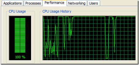
1a

Tabbed over to the Processes page and found that IE 8 was using the CPU like crazy.
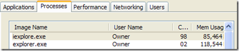
2

This obviously was a good place to test the sand-boxing capabilities of IE8. In theory, I should be able to shutdown the offending IE8 process and all my other IE8 tabs should still be up (living happily as though nothing happened to this way-ward sibling tab of theirs). That way - I wouldn't have lost the work I had done in the other tabs (finding links is a hard job - my friend).

So I sorted the CPU column to find the IE8 processes that was making the most use of the CPU. And found one that was constantly using more than 90% of the CPU. This had to be the offending IE8 process.
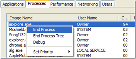
2a

I ordered a hit on the offender. So I right clicked on the iexplore.exe process and hit "End Process". Viola! the offending page was taken out of circulation.

IE8 sand-boxing works great. Did exactly what I expected it to do - it shut down the tab that had started misbehaving and still the other tabs were alive and usable.

Unfortunately, here is where a weird quirk of IE8 comes into play. IE8 detects that something happened to that tab and automatically resurrects it. And as it resurrects the misbehaving web-page - it puts me back in the same place I was, before I killed off the processes.
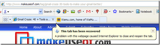
3

In my opinion - IE 8 should have asked me if it should respawn the IE8 tab with the link that was causing problems. By not doing so - I was put in never ending cycle of kill process, process respawns to open same link, CPU spikes to 90%, kill process again. Finally I had to choose "End Process Tree" - which resulted in the entire IE 8 shutting down and I lost all the "work" I was doing on the other pages.

So Microsoft - here is a feature suggestion: check with the user if they would like to reopen a tab that just went down because of a "problem with the webpage".

(Not sure what is weird about that page - but even in Chrome - it spikes the CPU usage graph - but not for as long as it occurs in IE 8.

Friday, September 26, 2008

Best practices for working with DEMs

etna_demA good article from ESRI’s mapping center on best practices for working with raster elevation data-sets (DEMs). Mapping Center.

  1. Manage DEMs in their native geographic coordinate system
  2. Standardize names of your DEM files so that it is easy to determine units and point spacing
  3. Always keep an original copy of the DEM .in the original geographic coordinate system. Use this to create any derived data-sets in a new projected coordinate system.

Some points that I would add:

  1. Get your provider to provide you with meta-data about the DEM data-set. One of the most important pieces of information that you should get is the point spacing that was used to capture the data-set. Knowing what the point spacing was, allows you to determine what sort of work you can do with the DEM. (eg: you cannot get buildings out of DEM that was captured with a point spacing of 2 meters).
  2. When creating tiles – try and cut the tiles such that they are homogenous in the kind of features that they contain:
    eg: don't cut a tile such that one portion contains an urban center and the other contains mountainous terrain or dense forests. This is because when you perform geo-spatial analysis – extracting features will become difficult as you will need to use different settings on these different types of geographic features.
  3. If you are going to get elevation data – then try and get it with the original point cloud. Having the original data from which the DEM was created will allow you to use the widest set of tools for processing your data. (Also, most new algorithms that come out are based on processing point clouds as they have a lot more precision).
    But remember, just because you have a DEM, or you are using a raster based algorithm for feature extraction – you aren’t working with less precise data. Precision in derived data from your elevation datasets is based on the features you are trying to extract. (eg: bare-earth and most building footprints can be extracted from DEMs with a comparable precision to that of bare-earth and building footprints extracted from point clouds).
    LIDAR Analyst has proved time and again in many studies – that you can have a high degree of precision and accuracy when processing and extracting features from DEMs.
  4. If you are getting new data – attempt to get the lowest point spacing that you can afford. Even if you dont need it for your current application. I have seen many times where organizations get lower resolution data which is cheaper and maybe sufficient for the current work that they are doing, but useless a year later when they try to use the data for some other purpose. (Most often the case is that LIDAR data was acquired for performing flood modeling for which 2 meter point spacing or higher can work, and later when they try to extract building foot-prints – the data is pretty much useless except for the larger buildings).
  5. Learn to setup your DEM for visualization with a hill-shade layer in traditional GIS applications. (In ArcGIS, this involves setting the DEM layer to have a transparency and has a hill-shade layer below it). This can make a world of difference in being able to differentiate and find objects visually.

QCoherent Software announces the release of LP360/Classify Version 1.6

lp360_dvd_adQCoherent Software, announced the release of LP360 v1.6 and LP360 Classify v1.6 today.toolbelt

New features in LP360 v1.6 include:

  • LAS 1.2 Support
  • Enhanced Export Features
  • Quick Display Filters and Copy Legend Options
  • Draped Profile Lines by Point Source (flight line) attribute
  • Integrated ArcGIS Breakline Digitizing tools
  • On-The-Fly Topology Corrections for Breaklines

http://www.qcoherent.com/news20080926.htm

If you process large amounts of LIDAR data then in my opinion I think you should have both LIDAR Analyst and LP360 in your tool-belt.

vls  LIDAR Analyst provides you with automated tools to perform classification on large elevation data-sets (both point clouds and DEMs). But as we all know - any automated tool, will make mistakes. It is for those cases that a tool such as LP360 becomes extremely useful. As an interactive editing and QA/QC tool - LP360 is one of the best I have seen. It handles the display of really huge point cloud efficiently and provides you with an awesome set of tools that allow you to leverage your classified data (that LIDAR Analyst output).

And now with the release of LPObjectsT (their API into LP360), you can create new tools that use both LIDAR Analyst features (through the Feature Analyst API) and LP360 features using their new API.