
In my last post, I compared the custom map facilities provided by Google and Microsoft in their online products. In this one I add my thoughts about Yahoo's custom map tool called MapMixer.
Now MapMixer doesn't seem to have the ability to add points, lines and polygons. So to do something like I did in Google Maps and Live Maps - create a list of RTD Light Rail Stations in Denver - doesn't seem possible in Yahoo! right now. On the other hand MapMixer allows you to very easily overlay your own imagery on their maps. Basically you upload your imagery - create 2 tie-points - provide some descriptions and you are done. So MapMixer allows you to create some very cool custom maps. But if you have seen my earlier post - not all imagery can be overlaid easily - and one doesn't always have custom imagery to make custom maps. So either Yahoo! is very quickly going to add the ability to define points, line and polygons or Google or MS might add the ability to add custom imagery overlays very soon in their products. (MS has a tool called MapCruncher that allows you to create tiles out of your custom imagery as well as use complex transformations to get your imagery to fit over theirs - but without them hosting the data - I don't see very many people using that tool.)
As for the data quality:
For the University of Montana, Missoula, Yahoo! has the latest imagery: The journalism building is complete. (In Microsoft the building is in its final stages of completion and in Google - the ground has been cleared but the building hasn't started yet). But Yahoo's imagery does not seem to be of the high-resolution that Microsoft has. (Google's imagery seems to be the lowest in quality of the 3 for Missoula).
 Yahoo! Maps

And when it comes to Denver here is Yahoo's imagery:
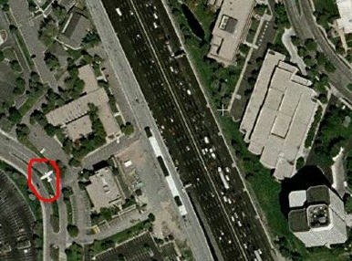 (Check out the red circle - there is a plane in there!)
And here is Microsoft's and Google Map's respectively:

Microsoft wins hands down in having the latest imagery as well as the highest resolution imagery. (Yahoo and Google both seem to have captured their imagery at the same time - but Google's imagery is clearer).
Oh! btw, let me add a disclaimer here:
The evaluation of the imagery between the 3 providers (Microsoft, Yahoo and Google), is by no means scientific. It is completely qualitative and based on 2 areas that I have an interest in - Denver (where I live and hence use the maps to find locations everyday) and Missoula (where I studied, where my company is and so I check out the maps every now and then just for nostalgia). I know both of these locations well and hence by looking at the imagery can make a fair guess as to when it was taken by seeing what is there and not there (which is why you see the above 2 locations - in Denver the RTD stations were completed about a year ago - and in Missoula, the journalism building was also completed about a year ago).
No comments:
Post a Comment